Thread Through Time: The BCER in North Saanich (PART 2)
by Edward LeSage
In Part 1 of the Spring 2026 edition of North Saanich Currents, you explored the British Columbia Electric Railway (BCER) in North Saanich, following the railway’s path station by station from the municipality’s southern border to “Sidneway” station on today’s airport land. Part 2 of this tale continues the journey to the “Deep Bay” terminus at Deep Cove, with attention to period and present features of the route, ambitious unrealized plans, and two mysteries.
A SECOND VIEW OF THE AIRPORT LANDS RUN, MEADLANDS STATION, PATRICIA BAY
Part 1 concluded by inviting North Saanich flaneurs and flaneues to view the railway-cum-runway alignment of YYJ’s Runway 14/32 from the “Rail History” interpretive sign on the south side of the airport’s Flight Path trail. A second perspective is obtained from the north: stand safely on the trail directly across from the intersection of Mills and Wilson roads and look south down the length of the runway. This view will provide you with an extra appreciation of the interurban’s route across what is now airport territory.
A pivot toward Wilson Road reveals how the railway, followed later by the adjacent road, continued northward in a gentle descending right-hand curve. Such curves are among the clearest surviving clues of former railway alignments. The curves are defined, in significant part, by engineering requirements of rail vehicle wheelsets. Central Saanich’s sinuous Wallace Road demonstrates the best examples of railway curves on the Saanich Line; in North Saanich, similar curves are found on Wilson, Mainwaring, and Tatlow roads.
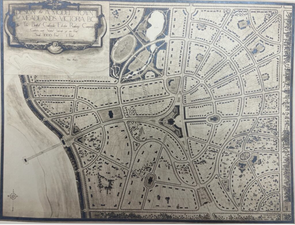
From the intersection of Mills and Wilson, you can envision “Meadlands” station at Mile 19.4, alongside the BCER tracks and high-voltage transmission lines of the day. BCER purchased the 350-acre Meadlands Farm property with high ambition: the company envisioned port facilities at Patricia Bay and a supporting townsite extending across and beyond the farm. Today, it would extend east beyond the District of North Saanich’s offices. Figure 5 shows the company’s unrealized 1912 “Garden City” plan for the port facility and Meadlands townsite.
MYSTERY #1: A PUZZLING FOOTPATH
This never-realized plan leads to the first mystery. A flaneur/flaneuse on Tseycum Road finds the road unexpectedly interrupted by a narrow footpath. By logic, the road should continue unbroken. While paths link roads throughout North Saanich, they are usually of some length and connect two roads; the Tsaycum Road path is only thirty metres long. Something odd is under foot.
Maps and other sources provide a partial explanation. The break and path sit on a cross-section of the old BCER right-of-way where a spur line was built to then Union Bay (now Patricia Bay). The Figure 5 town plan clearly features the spur and a wye, the only elements of the Meadlands town plan built. That spur branched off the Wilson Road main line and ran about a mile across Meadlands Farm land to the Bay; today, the path is the most visible surviving reminder of that built spur.
The spur’s most publicized use came early, when Premier McBride and carloads of dignitaries travelled along it to a viewing platform overlooking Patricia Bay after the June 18, 1913 “silver spike” ceremony inaugurating the Saanich Line. For today’s curious explorer, that end-of-spur platform – and the envisioned Patricia Bay wharf – would have been roughly at BC Transit stop #102306 on West Saanich Road between Tapping and Munro roads. The reason a public path straddles the old right-of-way, however, is a mystery itself.
MYSTERY #2: WHY THE WYE?
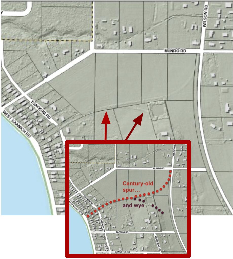
Figure 5 shows a large triangle of tracks at the heart of the townsite plan: a railway “wye,” an arrangement that allows a train to reverse direction through a three-point shuffle. A wye was unnecessary for BCER’s double-ended interurban railcars, but it would have been essential for freight trains pulled by a single locomotive. The most likely explanation for its existence is that the Meadlands/Patricia Bay wye was built in anticipation of cargo-handling port traffic that never materialized, making it a stranded asset. It may still have served limited operational purposes, including hauling logs, roughcut timber, or quantities of firewood harvested north of Patricia Bay. The wye might also have functioned as an overbuilt siding for rail traffic.
At ground level, excepting the Tseycum Road footpath, any evidence of the Patricia Bay spur and wye is invisible. Figure 6, however, uses layered imaging to reveal ghostly traces of the century-old alignment and shows how much of the railway’s footprint survives, if only as a rise in the landscape or on maps.
The First World War contributed significantly to the 1924 abandonment of the Saanich Line, but for a moment, in 1919, BCER appeared poised to benefit from the war. The federal government showed an interest in purchasing the Meadlands property to establish a working farm that would aid Great War veterans to take up farming on the Island. This initiative also never saw the light of day
A North Saanich explorer will notice that the transmission lines along Wilson Road, operated by BC Hydro (and inherited from BCER) appear about 250 metres north of the former Meadlands station. The transmission lines appear as if conjured up. In fact, these lines emerge from an underground cable that is buried because the power poles can’t be situated any closer to the airport – remember that the south end of Wilson Road is aligned with Runway 14/32.
Prior to the 1939 establishment of Patricia Bay’s RCAF airfield, BCER power lines ran in a straight line across the territory within the railway ‘s right-of-way corridor. (See Part 1, Figure 3) Airfield development pushed the lines to Canora Road and northward. Later, and as today, the lines ran buried under an extended (YYJ main) Runway 09/27 emerging adjacent to McDonald Park Road. From this point, the lines journey to their original corridor via Mills Road, with the first-mentioned short subterrain dive, before rejoining their old Wilson Road route. As noted in Part 1, BC Hydro lines are arguably the most visible legacy of the BCER in North Saanich.
GIBSON’S CROSSING AND MALLOWMOT STATIONS
Traveling north on the Wilson Road grade tracks and power lines arrived at John Road and “Gibson’s Crossing” station – Mile 19.8. This station was named after another senior BCER employee, Henry Gibson, BCER’s traffic superintendent in Victoria.
The North Saanich flaneur/flaneuse can easily access the Gibson’s Crossing station location and will note two things about the spot and its environs: the evident rural character, and its proximity to the Tseycum First Nations reserve. Land around Gibson’s Crossing was dedicated to farming and other agricultural purposes in the early years of the 20thcentury. This character remains with farms and ranchettes that are actively in use under protection of provincial Agricultural Land Reserve status. No mention of the Tseycum people is made in published accounts of the BCER Saanich Line, even though the railway ran close to Union Bay 4. Here too is something that begs future inquiry.
“Mallowmot” station (Mile 20.9 named after the late-19th and early-20th century Mallowmot Ranch) was situated at the intersection of today’s Wain and Tatlow Roads. Today’s Brackenhurst Farm (established in 1930 by the Aylard family) was carved out of the ranch. BC Hydro power lines still cross Brackenhurst Farm, and the Aylard family owners still refer to the old BCER corridor, appropriately, as “the grade.”
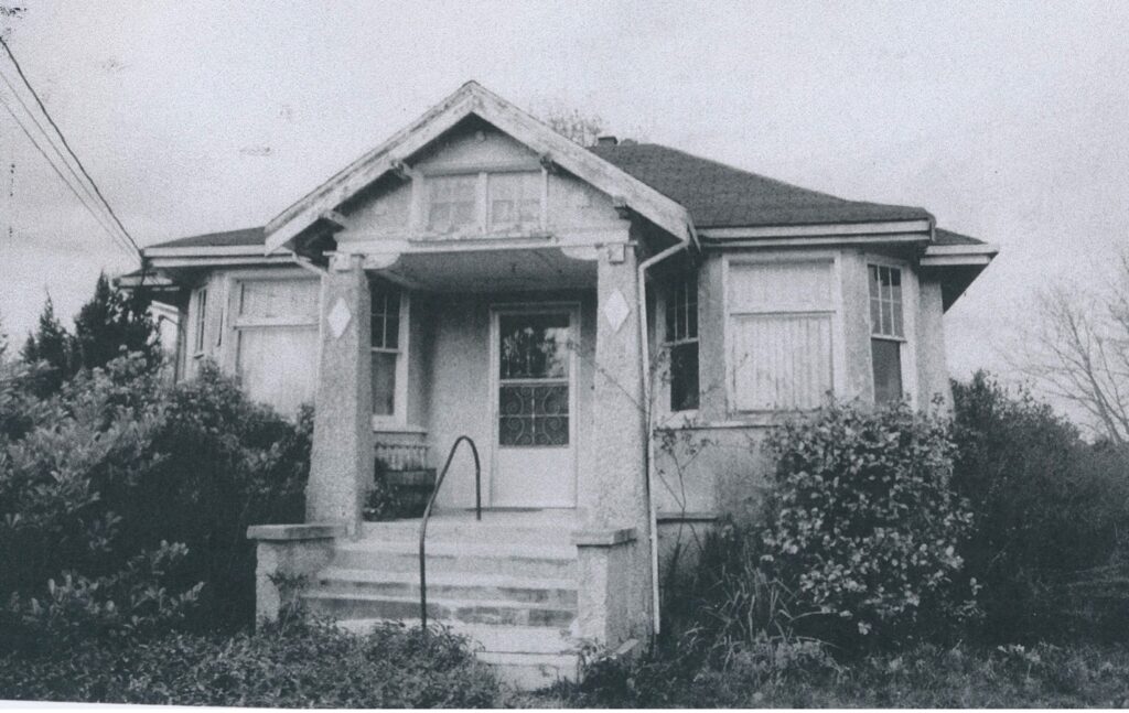
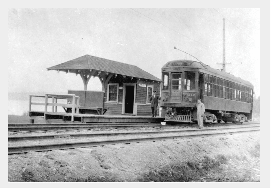
A fun fact is that the Mallowmot station was later repurposed as a pigsty and chicken coop on Brackenhurst Farm. This wasn’t the only post-railway use of the North Saanich stations. The Dominion Brook Park teahouse station’s afterlife is noted in Part 1 of this article. The Sidneway and Meadlands stations were integrated into a farmhouse that sat for years off Mills Road near the current site of the North Saanich District property. (See Figure 7) Finally, there’s a former North Saanich station that was repurposed as a cottage decades ago and remains in use today. There are likely more examples of these proud structures serving second or third lives along the old Saanich Line.
Mallowmot station served as an access point for passengers traveling east and west along Wain Road. Wain Road harks back to early European settlement of the area, reportedly first established in the 1860s. Mallowmot was also the BCER station that served South Gulf Island passengers taking inter-island ferries that sailed to and from Swartz Bay. Although some distance from Sidney, the Mallowmot stop was closer than Sidney’s V&S station and offered better rail service to Victoria and westside peninsula communities. Local island passengers were among the strongest petitioners for saving the railway when BCER announced plans to abandon the Saanich Line. Important to understand here is that this was before automobile-carrying ferries were in service.
TATLOW ROAD, TATLOW STATION, DEEP BAY STATION, AND DEEP COVE CHALET
Before there was Tatlow Road there was the Tatlow run of the BCER to the north of, then, Tatlow Creek down to Deep Cove. The wide Tatlow Road curve encountered when approaching Horth Hill Regional Park from the south is one of the previously mentioned railway curves. The road reveals its railway roots in other ways to: it runs close to raising land to the north on an alignment that boasts modest rock cuts. A probable explanation for this slope-hugging and the rock cuts is that the alignment is set on marginal lands either granted or sold by landowners. Property owners wanted to encourage railway building, from which they would benefit, while also preserving workable agricultural land whenever possible.
“Tatlow” station (Mile 22.3) was established the corner of today’s Tatlow and West Saanich roads. Robert Garnett Tatlow was an energetic and celebrated Irish immigrant military man, businessman, and public official. Of note here is his principled rejection of provincial government subsidies to railways. Tatlow resigned twice from governments objecting to subsidies. All the same, the company named the station and creek following his 1910 death in Victoria, at 53 years of age. Tatlow Creek was later renamed Chalet Creek – either way, the creek was stamped by the BCER.
Long-term residents who were raised in the Deep Cove area tell of Tatlow Road as a once narrow and rough road. One veteran resident speaks of family excursions to salvage discarded side-of-road wooden ties left for picking many year after the railway was abandoned. Another describes the Tatlow Road of his youth as narrow track that tunnelled under a thick over-arching tree canopy.
The last station of the North Saanich run, “Deep Bay” (Mile 23.0), was located steps away from Deep Cove’s Chalet Beach. The excursions to the end-of-steel beach were so popular that BCER announced plans in May 1914 (ten months after the line was inaugurated) to build the renowned Deep Cove Chalet. It was envisioned as a 23-room hotel and tearoom. The hotel was never built, but the tearoom and accompanying beach amenities were.
Building the Chalet and promoting beach excursions and recreational activities was initially a boon for weekend Saanich Line traffic. Multiunit weekend trains packed with day trippers and groups out of Victoria traveled to Deep Bay’s recreational amenities. It is useful to remember that the BCER was a business and it, like other interurban railways on the continent, grappled with reduced weekend passenger numbers and fare revenues. The Chalet and Deep Cove beach recreational opportunities were introduced to bolster rides and revenues.
BCER sold shoreline Deep Cove residential lots to Victoria families and others who traveled to these paradisiacal properties via the interurban railway. The properties were initially mostly occupied as waterfront cottage retreats which, before Chalet Road, were accessed by hiking from the Deep Bay terminal. With the improvement of local roads and highways overtime, larger and permanent houses have been built on the cottage properties, some of which were, and remain, occupied by subsequent generations of the original cottage families.
END OF OPERATIONS
A severe economic recession beginning in 1913 caused by the collapse of the real estate speculation bubble hit Victoria and the BC Electric Railway hard. This and other factors contributed to the eventual abandonment of the railway. The Great War was one of two of the most significant other factors. It diminished British investment in Canadian enterprises during and following the war, emptied the region of young men and arrested subsequent settlement, and moved industry and internal investment to Central Canada. The second was the burgeoning adoption and availability of automobiles and public investment in roads and other supporting infrastructure.
Schedule adjustments, one-man train operations, and several other strained efforts failed to stop the bleed of Saanich Line red ink, and on October 31,1924 operations of the Saanich Line were terminated.
Deep Cove Chalet and its shoreline property were quickly sold for $10,000.00. The railway declared that it was prepared to sell the right-of-way to owners of abutting properties at “a low figure” in recognition that much of that land had been donated by the owners. Elsewhere along the line, what remained unsold of BCER land purchased with enthusiasm in the early 1910s was for the most part sold off with other assets for what the market would permit.
An estimated 2,200 tons of rails were removed and most shipped to serve BCER’s widespread and much longer-lived Lower Mainland system. Saanich municipality acquired 14 miles of right-of-way for road building. A similar transfer did not immediately or wholly occur in North Saanich where no municipal entity existed. Bits of the North Saanich right-of-way corridor land remained in BCER (and successor public crown agency’s) hands for some time following. In fact, on the record, this still seems to be the case for a limited number of parcels even if North Saanich paved roads run over top!
YESTERDAY, TODAY AND TOMORROW
The history of BCER’s Saanich Line in North Saanich can be considered in different ways. For example, it can be thought of as a tale of Edwardian Period railway entrepreneur foibles; that is, of men who were driven, and perhaps blinded, by buoyant capital markets and galloping new technologies. It was a time of great ambitions and, undoubtedly, imperial hubris – worth remembering is that the Saanich Line’s formative year was 1912, the year that unsinkable Titanic went down and the shine of the Edwardian Period dimmed. There is value in understanding the Saanich Line tale to appreciate our history of that time. There is also value in considering the relevance of the hard lessons of that time for today.
Alternatively, the railway can be thought of as a vanguard of modernity and a primary agent of a new regionalism –the “sourdough starter” referenced in Part 1. Interurban railways brought electric power to town and rural residents – this was certainly the case with the BCER – and electricity in businesses and homes ushered in modern life. Interurban railways everywhere in North American unquestionably accelerated the creation of regional communities whose populations would be connected by comfortable rapid transportation. Enduring collective mental images of regional communities were promoted by this ease of movement within regions and accompanying social interaction and commerce. All this is true for Saanich Peninsula, although North Saanich admittedly might be the peninsula community least integrated into the regional gestalt. It is worth mention that North Saanich “exceptionalism” was evident during the railway’s operational years; weekend service was less frequent beyond Saanichton station (Central Saanich), and more infrequent yet on the line between Meadlands and Deep Bay.
The history of the BCER in North Saanich also should be considered as a layered tale. This article has been written with this firmly in mind. Today’s reality is that almost all evidence of the railway has been built over, removed, or moldered to remnants. And yet, it is undeniable that the physical and mental legacies of BCER’s thread of steel are permanently woven into the fabric of North Saanich. For this reason alone, it is appropriate to acknowledge its existence and contributions.