Thread Through Time: The BCER in North Saanich (PART 1)
by Edward LeSage
(revised June 15, 2026)
Preface from the editors: In 1913, the British Columbia Electric Railway (BCER) started the Saanich Interurban line, which operated from Victoria to Deep Bay (aka Deep Cove) in North Saanich. Although it was officially closed by 1924, the BCER route and infrastructure has left indelible imprint on the settlements of North Saanich. This idyllic line carried passengers and produce for slightly over a decade starting from Victoria all the way up to The Deep Cove Chalet and beach. Although, the economic and demographic shocks of WWI spelled the end of this line, the vestiges of BCER are embedded and can be found across North Saanich.
In his two-part essay, Edward LeSage takes you on a journey in time by uncovering the scattered remnants of a living history. In this edition of North Saanich Currents, you will find Part 1, which traces the railway line, by station, from North Saanich’s southern border to airport land. Part 2 will be featured in the summer edition, to continue this rail journey to the Deep Cove station with attention to intermediate stops and a historical mystery. LeSage invites the reader to virtually and actively explore BCER’s North Saanich route, vestiges, and our present-day built environment spawned by the long-gone railway with the hope that they will better know and appreciate our piece of paradise.
______________
INTRODUCTION
Three railways crossed North Saanich land during the second decade of the 20th century. Each took a different route from Victoria or Esquimalt up the Saanich Peninsula, terminating at different points in North Saanich or Sidney. The railways briefly competed for passenger and certain freight trade, but their principal purposes differed; the same can be said for their corporate and historical legacies.
This article focuses on the British Columbia Electric Railway, BCER, (1913-1924), which rolled from Victoria’s downtown terminal, ran to the west side of peninsula, crossed it, then looped west and north terminating at Deep Cove. It was a railway that was grudgingly built, constructed in part to serve larger political and corporate purposes and, arguably, from a business perspective, should have terminated short of Deep Cove, if not of North Saanich entirely.
Despite its relatively short existence, BCER’s Saanich Line remains the most significant railway in North Saanich’s development. It was built to foster settlement and economic growth, and to generally enhance the quality of regional life. The line was, metaphorically, a “sourdough starter” for our community. Today in North Saanich, a century after its operations ceased, roads and streets run over what once were rails and ties—then and now accompanied by high-voltage power lines. North Saanich neighbourhoods, properties, and major public infrastructure have been shaped by the BCER in ways that may surprise residents.
In considering the BCER legacy, we are reminded that human landscapes are rarely created from whole cloth; rather, they are complexly built in layers upon what has been previously constructed. This development often occurs in spurts followed by long periods of less pronounced and routine growth thereby giving considerable historical significance to short formative periods. The BCER was conceived and built during a historic spurt of economic growth on South Vancouver Island, which does much to explain its outsized influence on the spatial development and character of our community, and the value of knowing something of its history.
Let’s follow the Saanich Line’s 11-kilometre northward journey across the District of Saanich, stopping at each of the line’s ten stations. A period map (circa. 1923) of the route and most stations is provided as an aid to understanding the local geographic and organization of this article. (See Fig. 1). Reading the article with a detailed street map available, in hand or on screen, will provide an additional aid. If your interest is sparked, consider being a North Saanich flaneur or flaneuse and actively explore the BCER tread that runs through our community. “Stroll” the route in whole or, perhaps preferably and more profitably, in bits or by chance with promise of serendipity. You can “stroll” by four or two wheels, by foot or virtually.
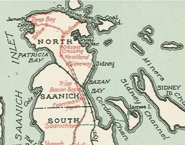
Figure 1. North Saanich BCER Stations (1923) [Courtesy of Saanich Pioneer Society Archives #F3029 S2]. Full version that includes Victoria can be seen here.
The BCER Saanich Line was a product of the “interurban age,” a brief time in North American railway history when investing in interurban railways was, truly, the rage. BCER rolling stock and infrastructure were leading edge interurban railway technology and, in hindsight, the Saanich Line represented an outsized investment for a lightly settled peninsula. Interurbans were electrically powered. The large coaches could run singly or combined as a train. (See Fig. 4.) Coaches were more powerful and faster than streetcars but could run on streetcar tracks and take power from the same wires. Operating outside urban areas (if built to high standard) interurbans could achieve high speeds while serving station stops spaced relatively closely. In the early 1900s, interurbans were superior to steam-powered railways in connecting moderately distanced urban centres and small town, and rural areas in between.
Importantly, the BCER was also an electric power company intent on providing electricity to Victoria, Oak Bay, suburban Saanich, and the rural Saanich peninsula. Additionally, BCER operated the streetcar system in Victoria and its surrounding municipalities. The octopus-like nature of these integrated BCER business foci are central to the Saanich Line story.
THE TERRACES NEIGHBOURHOOD AND THE EXPERIMENTAL FARM STATION
Our “stroll” begins where BCER’s interurban trains entered North Saanich’s “South East Quadrant” on Aldous Terrace from Central Saanich’s Wallace Road. At the time neither road existed, only the railway with its march of flanking power transmission poles. Just a bit downhill, tracks of the Victoria and Sidney Railway steam road, generally known as the V&S, ran parallel on what is today Bourne Terrace. Subsequent street and parcel layouts of today’s lower Terraces Neighbourhood were defined by the parallel run of these two railways.
Short of a kilometre into North Saanich, tracks and powerlines left the Aldous Terrace right-of-way to cross the Government of Canada’s Experimental Farm (presently, The Centre for Plant Health). The first North Saanich BCER station, “Experimental Farm,” was located at Mile 16.9 of the line. Mile 0.0 was the BCER’s Victoria terminal located on Douglas Street immediately across from City Hall, which suggests something about the political influence of the BCER enterprise. Victoria terminal was on a principal streetcar line, and this arrangement made for ready passenger connections between the peninsula’s interurban trains and greater Victoria’s streetcars.
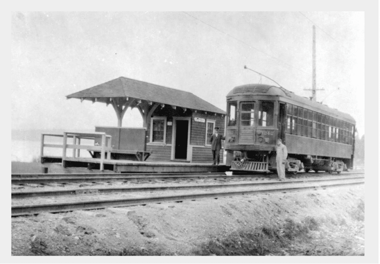
An appreciation the BCER’s path across the farm is gained by visiting beautiful Dominion Brook Park and walking down hill to the boundary fence. There you will see a parallel phalanx of utility poles running north/south across the field. Imagination can fill in tracks and a small station signed “Experimental Farm” that would have been roughly situated beside tracks close to the SE corner of the park’s fence. With closure of the Saanich Line, a BCER station was moved to the park to initially serve as a teahouse and later as a picnic shelter. (See Fig. 2.) Take a look at the park’s current picnic shelter, constructed in the 1950s, which architecturally salutes the BCER station shelter it replaced. With prospects of this structure being replaced some time in the future, one hopes that this homage will continue.
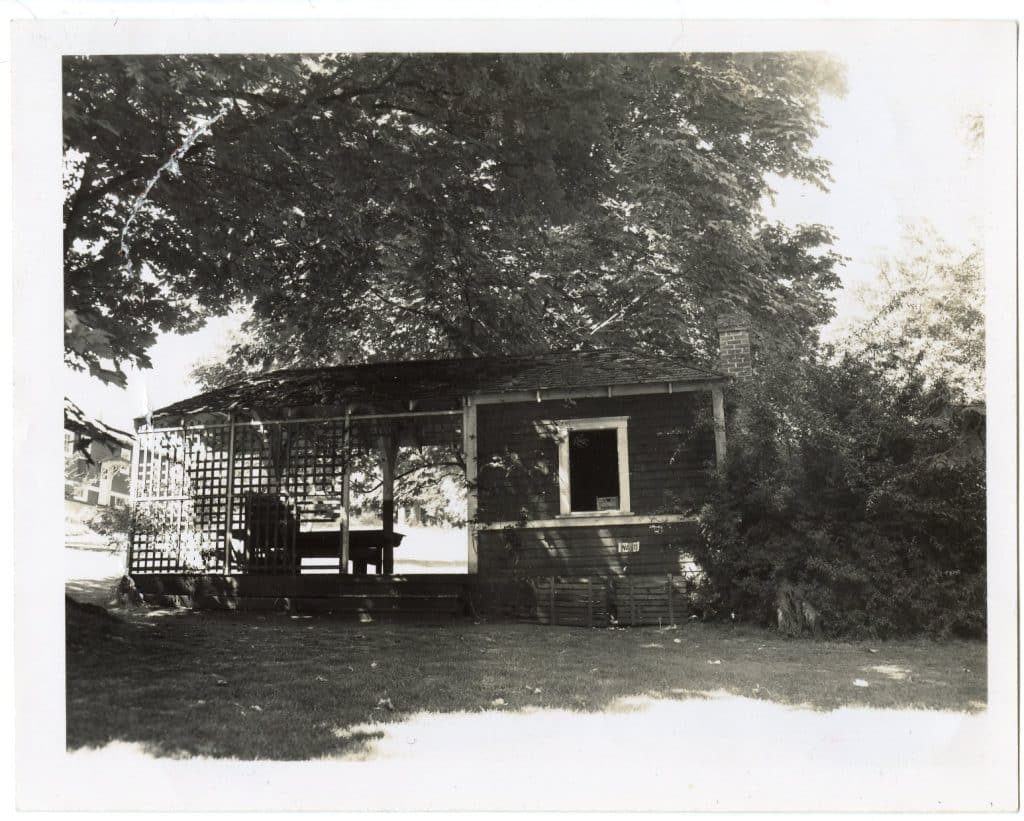
Figure 2. Former BCER Station used as Dominion Brook Park Teahouse. [Courtesy of Sidney Museum/Archives #P75.157.1]
The BCER sold experimental farm property to the federal government immediately prior to railway construction. In fact, the sale of land, which was in many instances the resale of recently purchased local properties, was considered essential to Saanich Line financing. BCER’s London-based board of directors had repeatedly rejected land speculation in financial plans for the larger BCER rail system, which served much of the Lower Mainland for decades before eventually ceasing rail operations in the late 1950s; however, boosters of the Saanich Line insisted that risk was limited in the greater Victoria area—Saanich Line approval and planning occurred during a brief and exceptional pre-WWI economic boom period. This boosterism was, unfortunately, misplaced.
BCER power lines and rails ran across the experimental farm during its early days, as did tracks of North Saanich’s two other railways. Dominion Brook Park (est. 1912) was an accessible and popular picnic stop for V&S and BCER day trip passengers. One can see why, since the park remains a delightful venue to walk and enjoy sweeping views Bazan Bay and nearby islands.
“BAZAN BAY” STATION, MAINWARING ROAD, BC HYDRO “SIDNEY” SUBSTATION
Leaving the Experimental Farm, interurban coaches sped along what is today’s Mainwaring Road to the “Bazan Bay,” station, located half a kilometre up the line at Mile 17.4, the intersection of today’s McTavish (then Breed’s Cross Road) and Mainwaring roads. “Bazan Bay” station served those traveling west on McTavish to area farms and West Saanich Road, and east to farm properties of the northern reaches of DNS’s “South East Quadrant” and the Bazan Bay waterfront. Property parcels later developed along the stretch close to the northern boundary of the federal government farm are irregular owing, in large part, to the railway’s slicing through standard rectangular grid surveyed land. This pattern is evident all along the line.
Mainwaring Road’s name reveals a BCER place-naming hubris. W.C. Mainwaring rose to vice-president of the B.C. Electric Railway, succeeding A.T. Goward who was a driving force for establishing the Saanich Line. Goward, himself, had a Saanich Line station bearing his name proximate to Observatory Road, which led up to the Dominion Observatory. Today, a B.C. Hydro substation located across Camosun College’s Interurban Road Campus bears his name.
Shortly before the former “Bazan Bay” station, you (our flaneur/flaneuse) will observe additional evidence of BCER combined railway and electrical power systems ownership and infrastructure—B.C. Hydro’s “Sidney” substation at 9110 Mainwaring Road. Although rails were long gone, the power line corridor in which the interurban line ran remained, and it does so to this day along much of the whole North Saanich route. This electrical power infrastructure was ultimately inherited by B.C. Hydro. Interestingly, in 1913, there was high expectation within the Sidney business community that the BCER power lines would enter the settlement with the coming of the railway to North Saanich. This happened, but initially Sidney’s main street lighting fell short of expectation and required annual merchant subscription drives to keep Beacon Ave. lighted.
TRIPP AND SIDNEWAY STATIONS
“Tripp” station, at Mile 17.8, was the next BCER stop north of “Bazan Bay.” Named after G.M. Tripp, BCER’s Vancouver Island general superintendent, the station was immediately to the east of today’s East Saanich Road and Willingdon Road (Airport) traffic circle. Mere metres from the station, the BCER and Canadian Northern Pacific Railway (but soon, following 1918 bankruptcy, to be part of the Canadian National Railway system) lines crossed with both lines heading in different directions across today’s airport lands. The CNPR/CNR line would travel straight to a long pier located on Patricia Bay, while the BCER would continue its northward journey to Deep Cove. See Figure 3 for a remarkable photo that clearly shows remnants of BCER and CNPR/CNR grades evident at bottom frame. Runway 13/31 (now renamed 14/32) shows at centre frame oriented vertically in the photo, and a faintly defined Wilson Road curving northward beyond the airfield boundary is evident at top of photo.
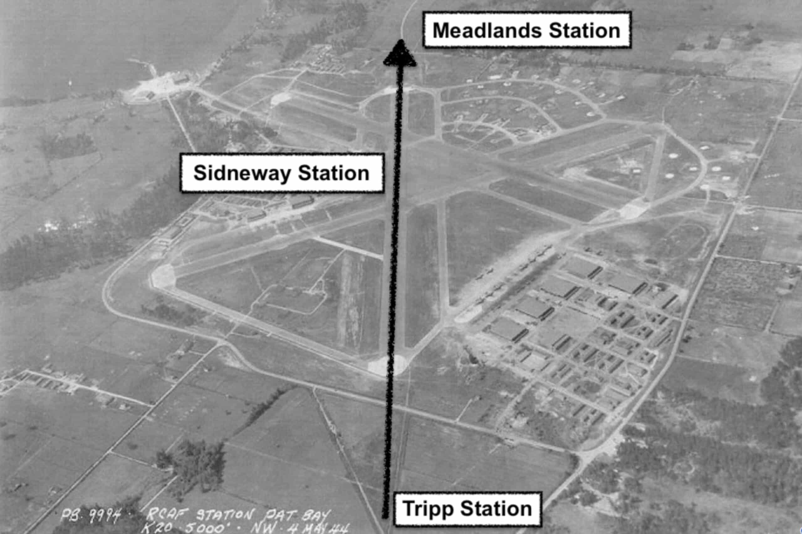
Figure 3. Patricia Bay RCAF Airfield (Circa. 1944). Online source. Patricia Bay can be seen at the upper left corner of image.
Leaving Tripp station, the interurban line arched northwest over today’s Victoria International Airport to Wilson Road on a grade that defined the orientation of today’s Runway 14/32. Halfway across, at Mile 18.8, was the inventively named “Sidneway” station. Sidneway was situated at the intersection an extended-into-the-countryside Beacon Avenue and Runway 14/32—roughly at the runway’s halfway mark. This thoroughly rural stop was a hike from Sidney, but for those making the trek it offered comfortable rapid transit to the heart of Victoria. Runway 14/32 is now a secondary runway and YYJ’s shortest.
Vestiges of Beacon Avenue’s route toward Sidneway remain visible today if you stand safely on YYJ’s “Flight Path” trail by the new “Amazon” traffic circle’s pedestrian crossing of Stirling Way and look west through the airport’s perimeter fence. You will see a remanent of an airfield road—in straight alignment with Beacon Avenue to the east—that disappears toward the middle airport land. This improvement was undoubtedly built upon the original Beacon Ave track to Sidneway station.
BCER never ran closer to Sidney owing to an exclusionary agreement that permitted only the V&S Railway to operate within the village. The BCER and CNPR/CNR were kept a mile distance from the municipality’s borders. (See Fig. 4) However, anticipating the V&S’s looming and seemingly much deserved bankruptcy, the BCER surveyed a grade leaving Aldous Terrace that would connect its line to V&S tracks and thereby enter Sidney. This connection was never built—Canadian Northern Pacific Railway made a better offer. This denied the BCER a desirable end-of-line “urban” anchor, an absence that likely contributed to, but by no means solely prompted, the line’s demise.
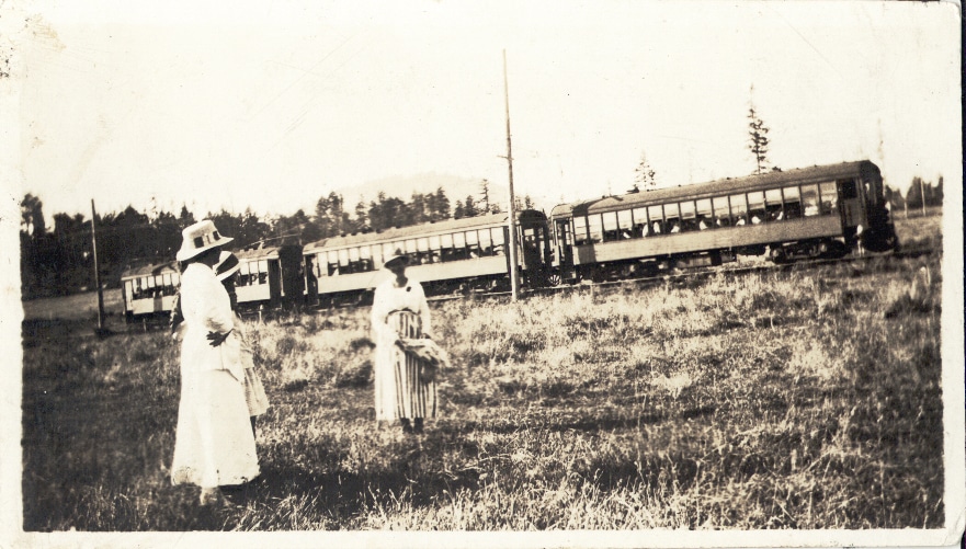
Figure 4. Three women and three electric coaches at Sidneway. [Courtesy of Sidney Museum/Archives P993.35.3]
Two recommended views of the BCER path across airport lands are offered to the intrepid flaneur/flaneuse. One is found on YYJ’s Flight Path trail, roughly 100 metres to the west of the E. Saanich/Willingdon roads traffic circle. Here an interpretative sign board installed by the airport authority provides information on North Saanich’s three railways. At this spot, look toward the Rotary Park baseball diamonds, and then slightly beyond and to the left, and you will see the south end of YYJ Runway 14/32. It is not surprising that the federal government drafted the former grade into runway service, Canada was severely pressed at the onset of WWII to develop RCAF Station, Patricia Bay. The old rail right-of-way provided a flat, straight, partially improved corridor that served the laying down a runway. The second view will be described in Part 2 of this article appears in the Summer 2026 edition of North Saanich Currents.
Part 2 of this article will explore the path of the BCER north of YYJ, with attention to what was, and what is, a mystery.